ZGUS Maps

Portable field map server project


  • Home

  • About

  • Contact

  • Recent

  • Tags

  • Categories

  • Archives

  • Search

Answers and Goals About the Portable Map Server Project

Posted on 2019-07-14

What is a Server?

In this context a server is usually an unseen computer on a network with no keyboard or screen and which, upon a valid request, either provides information, changes, adds or deletes information, further processes information or passes requests to another server. Usually there is nothing more than information involved.

What is a Map Server?

In the context of everyday use a Map Server can be defined as a server that will reply with geographically relevant information presentable in the form of maps, according to specific external requests over a network, such as from a client web browser on a mobile phone.

Can a Map Server work by itself?

At a literal level, no. It needs lots of other servers, such as a web server, a database server and caching services. It also needs to be on a network to be of any practical use. We use the term Map Server to also mean a minimum set of additional services to make the Map Server functional to a client web browser.

What is a Portable Map Server?

We define this as a small, light, low powered device without a screen or keyboard that can be esaily carried without damage, that runs a map server and can adequately respond to an audience that might be expected to use such a server, such as a group of 10 people in the field within range of server by WiFi. We also expect the portable server to be functional when out of range of Internet connectivity.

How can mobile phones continue to use a portable server when out of Internet range?

By having the portable map server connected to the same WiFi Hotspot Network as other devices, such as mobile phone devices. Just because the Hotspot is out of Internet range does not mean the devices connected to the Hotpsot are out of range.

Our post on Wide Mobile Coverage SIMs in Australia has more information on how this works

Don’t phone apps do the same thing?

In appearance and for some purposes yes. In functional and fundamental terms no. If you know exactly where you are going, are certain you won’t need to change plans and all your information is sufficient, know which phone you are going to use, don’t care it might get damaged or have its screen scratched, are happy you won’t need to swap it for another or borrow another as battery runs out, don’t mind figuring out if you have got the right set of downloaded data, are happy every one else is in the same position as you and won’t need to update data in the field (such as no one has data or will generate data that needs to be shared) then you are lucky and in a unique position. You will not benefit from using a portable map server, whose responsibility can be that of one single person (instead of everyone being responsible for downloading to their own phone before going out of range), which can be plugged into a good car battery, forgotten about or not know that it even exists and hardly drain the car battery.

Will build scripts be made available?

Probably but not anytime soon.

While the finished product is robust the build process itself is very fragile, has multiple parts with multiple complex dependencies and requires software to be built from source.

To maintain efficiency and keep resource use low, a good example is the web server nginx. Nginx is built from source. This allows a built module to tell nginx there is no cached map tile for a particular request so nginx can then instead pass the request, through fastCGI, to the real map server. This way nginx can continue to do what it does best without passing or queuing every single request for a map to a waiting fastCGI process or worse still, spawn a CGI process for every request.

We have experienced the entire edifice crashing down with a single apparently trival name change in a small glue or shim piece of software. This was difficult to track down.

Learning to build the map server took a lot of trial and error. We are still learning what all the dependencies do and as we learn more we are able to make the build process less fragile and so more suitable for scripting.

Releasing a fragile build script now would result in a support nightmare for us as we would be expected to support it.

Also the preferred operating system, Debian, has just has a major release (Buster), as well as Rasbian (used in field trials). We would like to see things settle.

What are the goals of the Map Server Project

  1. (Achieved) To build a reliable map server and associated software suitable for a portable server as defined above.

  2. (Achieved) Allow map server data to be displayed as a basemap, allow basemap to be changed, allow additional vector data to be displayed and allow extent of a view to be changed

  3. (Achieved) Allow GPS navigation with a track to be displayed when web page is in view

  4. (Not Started) To convert the map server build process to a non fragile build script

  5. (Not Started) Use a PWA (progressive web app) so there is still functionality when no portable map server is present and so an icon can be placed on home screen

  6. (Work In Progress) To allow a camera to be used within web page from which
    1. Colour effects can be added into image for live highlighting of camera imagery
    2. A photograph can be taken and saved as data
    3. GPS coordinates can be added as exif data
  7. (Work In Progress) Allow multiple types of data to be stored, downloaded, edited, generated, collected into a zip file and dispatched with additional comments. What this in effect means is that additional map data is controllable by the user, including what they do with the data. Data to include :
    1. Waypoints
    2. Routes
    3. Tracks directly from GPS or loaded and added to
    4. Arbitrary form data with form elements (what form requests) as a downloadable or settable resource
    5. Photographs and highlight settings for additional photographs
  8. (Not Started) Allow live sharing of data as generated among several users, if requested by user.

  9. (Not Started) Allow users to pass stored collected data back to the web server for storage and/or sharing with others

  10. (Not Started) Use the new Geolocation Sensor interface when available to allow GPS data to be collected in background

  11. (Not Started) Improve presentation and navigation of web site
Wide Mobile Coverage SIMs in Australia

Posted on 2019-07-14

Wide Mobile Coverage SIMs in Australia

Posted 14 July 2019, Updated 30 July 2019

tl;dr

In Australia 4G coverage is now larger than 3G coverage. This means in Australia coverage for data through mobile phones is now wider than coverage for voice calls through mobile phones. This should be taken into consideration when purchasing SIMs. Two SIMs in particular are mentioned with different functional coverage although on same 4G network.

Summary

Very cheap phones with dual 4G slots and 700Mhz coverage are now becoming available.

In Australia 3G coverage is now not as good as 4G coverage with Telstra. There are likley still some areas where 3G coverage exists but 4G coverage is absent.

The other two providers, Optus and Vodaphone now have excellent 4G coverage in urban areas.

4G coverage without VoLTE enabled AND where there is no 3G coverage means SIM based phone calls and SMS/MMS cannot be sent or received. It does not matter if your phone is VoLTE enabled or not, the service provider must also enable VoLTE for your SIM.

The SMS/MMS replcement, RCS, does not require VoLTE. Because RCS in Australia is basically a failure (see below) and since VoLTE (see below) is a limited 4G add on service, 3G is still needed for SMS/MMS messaging when VoLTE is not available with 4G.

ALDImobile SIM

A good buy for wide 4G coverage in Australia without VoLTE.

Suitable if you have a cheap Android 4G capable phone, don’t need to make voice calls and don’t need SMS/MMS and are happy with social media or chat apps such as Telegram

Also suitable if you use iMessage, all your friends, family and other contacts are iMessage users then all you need is wide 4G without VoLTE.

AldiMobile provide very inexpensive prepaid SIMs that enable very wide 4G coverage but without VoLTE.

ALDImobile indicates their coverage is not as wide as the full Tesltra coverage. Tests show that neither their 4G or 3G coverage is as wide as full Telstra 4G and 3G coverage. If 3G coverage is absent where 4G coverage is present you cannot make phone calls or send/receive SMS/MMS over 4G with ALDImobile, even if you have a VoLTE enabled phone.

Coverage through Woolworths SIMs appears to be the same as through ALDImobile SIMs.

Boost Mobile SIM

A good buy for wide 4G coverage in Australia with VoLTE.

If you need SIM voice calls, SMS/MMS and data then you need 4G with VoLTE and a recent phone that is VoLTE enabled. Boost Mobile provided prepaid pins that are functionally equivalent to both postpaid and prepaid Telstra SIMs.

Comparing SIMs

Telstra, Boost Mobile, ALDImobile and Woolworths all use the Telstra 4G network. The Teltra 4G network is the only one with rural coverage and this is reflected in higher charges to use their network. Of the four, Telstra SIMs are the most expensive. Boost Mobile have straightforward prepaid plans, including 365 day plans. Woolworth prepaid plans are normal monthly type plans but working out the monthly price after the first few months is not obvious. ALDImobile have a flexible but odd arrangment. They have a low cost but high charge PAYG (pay as you go) base plan upon which you can add packs at cheaper rates, typically monthly. If you have exceptionally low usage it is theoretically possible on ALDImobile to pay $5 for your first year (including cost of SIM) and $15 per year after that on a PAYG only plan.

What are the differences between Boost Mobile and Telstra prepaid SIMs?

  • Boost Mobile 4G speed limited to 100Mbps?
  • Telstra SIM provide access to Telstra Air WiFi network that includes Fon access
  • Discounted tickets and data free access to some sports events?

Mobile data versus WiFi Hotspots

With cheap mobile data it is now less of an issue to put up with the inconvenience of finding and using free WiFi access, when mobile access is available.

If you still want to use WiFi access points instead of mobile data there are multiple choices near city centres, typically cafes.

Inconveniences of WiFi access outside a home or work environment include drop outs, slow speeds, highly limited range and limited accessibility.

What SIMS support VoLTE (Voice calls and SMS over 4G)

  • Optus
  • Vodafone
  • Telstra
  • Boost Mobile (uses Telstra network)

What SIMS support VoWiFi (Voice calls over WiFi)?

If your SIM does not support VoLTE then it is unlikely to support VoWiFi.

  • Optus postpaid only?
  • Vodafone postpaid only? Vodafone prepaid does not support VoWiFi
  • Telstra
  • Boost Mobile (uses Telstra network)

What inexpensive phones support 4G LTE?

The Umidigi A5 Pro was on presale at US$99.99 on AliExpress, reached a presale count of 27 000 and is still climbing.

This phone has been tested. Besides listed attractive features such as dual 4G slots, LTE Band 28 (700 MHz), 4GB RAM, 8 CPU cores, 32GB Flash and triple cameras, the A5 Pro surprisingly supports Camera2 API as well as OpenGL ES 3.2 and Vulkan with its Mali G71 GPU.

The phone supports the MTK chip service mode code *#*#3646633#*#* and this was used to verify with Telephony, BandMode that both SIM slots support 4G LTE band 28 (700 MHz).

Both VoLTE and VoWiFi have been confirmed to work.

There are no notification LEDs on the phone. However notifications can be received on inexpensive watches such as the Xiaomi Huami Amazfit Bip and Umidigi Uwatch2.

Some terminolgy is outlined below

WiFi

A serivce to enable data to be interchanged without wires. Typically uses 2.4GHz and 5GHz unlicesnsed radio frequency bands. A SIM card is not required to use WiFi. You can leave a SIM out of a mobile phone and still use WiFi for Internet, but not make or receive normal voice calls or SMS/MMS that rely on SIM for identification.

Mobile phones will also allow SIMs to be turned off with WiFi turned on or allow flight mode to be entered with WiFi subsequently turned back on (which leaves SIMs off). With SIMs off and WiFi on, Internet can still be accessed. This can help dramtically save battery power.

SIM

A small card that plugs into mobile telephones and other mobile devices enabling electronic identifcation of a subscriber to telephone and data services through mobile phone telephone towers. In Australia typically associate with a 10 digit phone number starting with 04.

WiFi Network

A service provided by a WiFi device that allows multiple WiFi enabled devices in range to communicate with each other, including itself. A SIM card is not required.

WiFi Hotpsot

A WiFi device, typically a modem, sometimes a mobile phone that forms a WiFI network and also allows connection from other WiFI devices to SIM based data services.

Public WiFi hotspots typically do not encrypt connections to them, meaning any sensitive data that is not encrypted can be exposed. Not as big a hazard as before when web sites did not force use of https, meaning users are being forced to encrypt. However care is still required. WiFi networks that force all connections to be encrypted will always require a password to be entered to access the network

Helpful to save power. In a remote location with very marginal 4G reception a data modem or WiFi spotpot with a good antenna can be left powered by a car battery while others with mobile phones can enter flight mode and just turn on WiFi, helping save their batteries from being quickly drained by weak signals.

3G

is a SIM based communication technology, primarily focussed on providing normal telephone voice call and SMS/MMS messaging services. An additional service is Internet based data services.

4G

is a SIM based communications technology primarily focussed on Internet based data services. An add on enhancement is VoLTE

VoLTE (Voice ofer LTE)

An additional SIM based service that may be available with 4G that enables 3G type voice and SMS/MMS services to be made available over 4G. Will then only use 3G for voice calls and SMS/MMS if 3G is present but 4G is too weak.

VoWiFi (Voice over WiFi)

A voice service that may be available provided a SIM is inserted in a device, WiFi is available and there is no 4G or 3G signals present or they are weak. VoWiFi is for SIM based voice only additional service. It does not enable SMS or MMS. SIM just needs to be inserted, the SIM does not need to be turned on or active. Flight mode can be active with just WiFi turned on. The phone with VoWiFi can access a WiFi hotspot but it will not use the SIM of that WiFi hotspot for call identification, it will use its own non active SIM.

VoWiFi is very helpful for saving power in remote locations with weak signals.

RCS (Rich Communication Services)

A competitor to iMessage by Apple. RCS is an IP or true Internet based SMS/MMS/Chat service with proven delivery using telephone number as ID. RCS is known as Chat by Android.

Might work in Australia with Telstra between some expensive older phones, such as S7, that are no longer updated or no longer receive updates.

A big disappointment. Around since 2007, has been forgotten about in the hype about 5G and since other chat services have left RCS behind in the dust, such as Telegram.

As of July 2019, Goggle is attempting to fix issues by bypassing telephone companies. These fixes are being trialed in the UK and France. Hopefully there will be a worldwide fix by late 2019.

Basemap, Map Legend and other improvments for nq field test maps

Posted on 2019-05-24

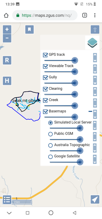
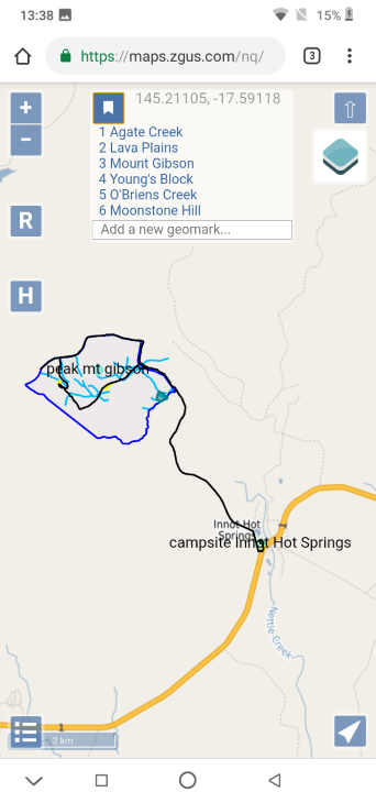
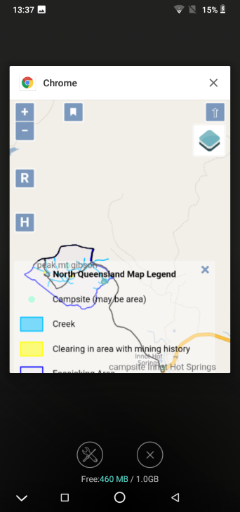
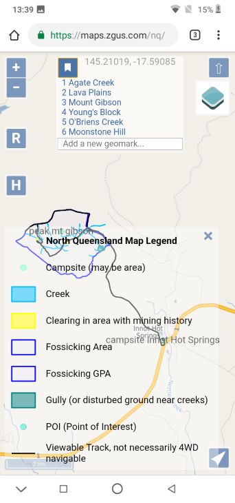
Screenshot images below show new map legend and new basemap/layer choices menu for the NQ field test site maps /nq with information at /maps-nq. Some information has been updated in the last link to reflect changes, for example use of .lan instead of .local for DNS while reserving use of .local for mDNS.

The screenshots were taken by holding down the power + volume down buttons on a very inexpensive and resource limited Android GO phone with 1GB RAM and 16GB flash memory, the Blackview A60.

The fourth screenshot shows 460M MB free of 1.0GB at the end. This shows one of the advantage of using a map server: very inexpensive phones can be used in the field with little concern about the consequences of damage to the phone with field use as they are so inexpensive. While the map server in the field does not require a mobile phone to use a SIM card and so have mobile access, the Blackview A60 does not support 700Mhz 4G LTE band 28 (common in rural Australia). However, there are inexpensive phones now coming on the market with dual 4G LTE SIM slots that includes 4G LTE band 28, for example Umidigi mobile phones (so far untested).

The rpi3 server documented in Field tests is now running Rasbian Stretch Lite OS instead of unsupported prerelease Debian Buster OS. The server is now stable. There is little practical difference between Rasbian Lite and Debian without a GUI installed, although enough to be an issue.

It has been noted using rpi3 can result in inconvenient delays when map tiles have not been cached.

The web server that is local with the map server is now allowed to wait for up to five minutes for a response from the map server to an individual request before giving up.

This timeout will help cater for those who might want their web browser to build up a cache of map tiles at different zoom levels and different nearby map locations while in the field, so they can temporarily go out of range of the map server and still find their phone usable with GNSS/GPS. The timeout also caters for extreme and impractical zoomed out panning.

With regard to saving information, currently different map extents can be bookmarked, as mentioned. To save a GNSS/GPS track with the map server currently the most convenient method is to take screenshots as required.

Field Test Details

Posted on 2019-05-09
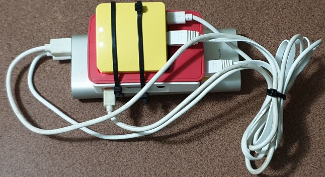
  • Silver item is a power bank
  • Red item is a Raspberry Pi 3 (rpi3) running unofficial and unsupported preview of Debian Buster, Debian on the Raspberryscape: Great news!
  • Yellow item is a GL.iNet GL-MT300N-V2 router.

Since this was a field test for development purposes and as part of development we are concerned with standardising the portable map server for use on an OS with widespread and accepted use, we are pleased the portable map server was able to run on an unoffical and unsupported version of Debian for rpi3, no matter how currently unstable, rather than the official Rasbian OS.

Not surpsrisngly there were OS stability issues arising from the use of a currently unstable prerelease OS that are not present when used with a stable OS: the portable map server required regular reboots.

The portable map server has run or is currently running sucessfully with Debian on cloud servers, Debian on Hyper-V on Windows 10 on Intel, Rasbian on rpi3 and rpi0. Attempting to use a map server on an rpi0 is not recommended. It is dramatically more sluggish than using with the rpi3, which itself is sluggish. The main advantage of use of an rpi3, depsite sluggish repsonse when a tile map is not cached, is low power, small size and low price.

While the rpi3 is capable of running as a WiFi access point without a router, using a router allows flexibility to swap in and out servers and not be concerned with differences between servers. Also it allows the use of WiFi access with different range capabilities.

default field test area in Northern Queensland,

Posted on 2019-05-02 | In Maps , News

Posted 2 May 2019

Maps of additional six selected areas in Northern Queensland for portable map server field testing purposes is now available from maps.zgus.com/maps-nq. Actual maps at maps.zgus.com/nq.

Field Testing North Queensland (NQ)

Posted on 2019-05-02 | In Maps , News

Portable Map Server Field Test Areas, Updated 28 May 2019

This is the help and home page for six areas in Northern Queensland that are default field test areas for the ZGUS portable map server.

They correspond to six state regulated areas set aside for recreational and tourist fossicking. A licence is required to fossick in these areas. Downloaded information.

Simulated local server links if on Internet (.com)

  • Maps Home Page maps.zgus.com
  • North Queensland Selected Areas
    • Help maps.zgus.com/maps-nq
    • Maps maps.zgus.com/nq
  • Coober Pedy
    • Help maps.zgus.com/maps-cp
    • Map maps.zgus.com/cp

Real local server links when not on Internet (.lan)

  • Maps Home Page maps.zgus.lan
  • North Queensland Selected Areas
    • Help maps.zgus.lan/maps-nq
    • Maps maps.zgus.lan/nq
  • Coober Pedy
    • Help maps.zgus.lan/maps-cp
    • Map maps.zgus.lan/cp

How to access the local server

  1. Look for a WiFi access point with name similar to zgus1234. For password use the name.
  2. When connected, access https://maps.zgus.lan/nq from a web browser
  3. When accessing for the first time, warnings will appear because your web browser will not be able to verify security certificates for secure access to maps.zgus.lan. Click on ‘Advanced’ or similar.
  4. Click on ‘Proceed’ or similar.

How does this work?

The following is in addition to broad information in section ‘Map servers in the field’ on maps.zgus.com. Also on maps.zgus.lan

A nameserver runs on the portable map server. The WiFi access point of the router is configured to offer your device the address of the nameserver as a nameserver when you connect (provided you are using DHCP which if you don’t know what this means, means you are using it).

The name server translates zgus.com.lan to its own address for the web server. While it seems easier to just let the nameserver lie and use maps.zgus.com instead of maps.zgus.lan, so avoiding dual links and avoid having the browser complain and issue dire warnings, it unfortunately reduces the likelihood that potential problems can be quickly and easily solved. 100 problems quickly solved, easily solved and easily learnt how to be solved in the field is preferable to one stressful problem requiring complex investigation, a lot of time and a high level of skill and experience. The field is not head office land where IT support can be summoned at the click of a finger.

In addition an mDNS service also runs, allowing use of domains maps.local and just maps (for example https://maps) instead of domain maps.zgus.lan. This service is not emphasised as mDNS use is not compulsory. If an OS or browser allows use of mDNS it is considered a convenience favour. For example mDNS works for PCs but not Android phones.

Usage

Please see /basemap-map-legend-and-other-improvements-for-nq-field-test-maps for screenshots

  • On phones two fingers can be used to zoom in, zoom out and rotate map. One finger can be used to pan map.
  • On desktop PC the left mouse button can be used to pan, the mouse wheel can be used to zoom and the shift key with left or right mouse button can be used to rotate.
  • The H button (for home or help) will take you to this page
  • The R button (for reset or reload) will force a full reload. This will remove GPS tracks so take a screenshot first if necessary. Currently there is no facility to save tracks.
  • The bottom left has a scale and a button to show a map legend. The map legend can be collapsed by pressing or clicking on x. The map legend shows scale below legend when legend shown.
  • The top right has an arrow symbol to reorient map to North upwards, the default position. There is currently no facility to allow map to automatically rotate while navigating. Manual map rotation is allowed (two fingers on mobile phone screen or shift key with mouse on laptop).
  • Below top right arrow is an icon with image of squares in layers. It is called the ‘layer switcher control’. Pressing opens up a menu to turn on or off selected layers and to choose one of several basemaps. Each layer and basemap can have its transparency adjusted with a slide bar. The order of layers and basemaps can be changed by dragging vertical arrow on right. A GPS track, if generated, can be converted to a layer and can be hidden and shown again.
  • The + and - symbols on left allow map to be zoomed in and out without using two fingers or the mouse wheel.
  • Can pan and zoom the map to the six different areas within North Queensland using the bookmark facility accessed from bookmark icon near top left. Can add and delete the current map view you are on to the bookmarks. Added and deleted bookmarks are saved by your browser. The map server has no knowledge of your bookmarks. There is no login to the map browser. If you use the same device and do not delete browser local storage then the bookmarks will reappear. Note bookmarks set when on maps.zgus.com do not carry over to bookmarks set when on maps.zgus.lan, as well as the other way around.
  • The navigation icon on the lower right allows live GPS tracks to be viewed on your browser. Recording of view can be paused. Be aware if you refresh the page the track disappears. The track is currently not saved to browser local storage and the map server has no knowledge of any tracks you recorded. If you need to save the track then take a screenshot (vol down + power buttons held down). The layers menu allow you to hide and show ‘historical GPS tracks’.

GNSS/GPS Tracking

The GNSS/GPS facility can show you your location on a map. There is a facility to draw a history of your past locations on your map, called tracking.

The primary purpose of this tracking facility is to help with data collection by converting started and stopped tracks into features of one or more layers, a facility that has not been implemented yet.

For example, if implemented, walking around a boundary of a culturally sensitive area would enable that boundary to be added as a polygon feature of a layer documenting culturally sensitive areas for the purpose of conducting a Native Title survey to be used in an ILUA (Indigenous Land Use Agreement). The end of the section further mentions data collection issues.

Another example, if implemented, is to collect information to investigate if some activity is in violation of agreed boundaries by simply walking around the area of the activity. In fact the existing facilities will allow this to a limited extent (no coordinates provided) by refreshing, starting a track, walking around, stopping track, taking a screenshot and providing an appropriate file name for the screenshot.

This primary purpose of data collection is the reason for a distinction between a live and historical GPS track outlined below.

Currently all started and stopped track line segments are combined together into a ‘MultiLine layer’ historical GPS track (called ‘GPS Track’ in the layers switcher control) and currently there is no facility to add in any other information, such as information about a feature added.

For the purpose of clarity, a track that is currently being recorded and that can be included in the historical ‘GPS track’ layer when recording has been stopped is called a ‘live GPS track’.

While the GNSS/GPS tracking can appear to act as if it tracking like a conventional GNSS/GPS device or app, it can only add track points while the web page is visible on the screen. When the page is not visible tracking is in effect paused. Also, currently, refreshing a page loses all track records.

If you need the functionality of a GPS device or app that can record tracks in the background then you need to use such a device or app in addition.

Clicking the GPS icon on bottom right wil show two further icons. You need to give permission for your web browser to track location. The right red button will start recording a ‘live GPS track’ with a blue dot (no movement assessed) or a triangle (movement assessed), indicating current location in the center of the screen. Pressing the right button again will pause recording, which can be resumed. Pressing the left button will stop recording a ‘live GPS track’ and the finished line segment into the historical ‘GPS track’ MultiLine layer. The historical ‘GPS track’ MultiLine layer is thinner than a current ‘live GPS track’ line segment.

The thinner historical ‘GPS track’ line can be hidden from view using the layer switcher control. The layer switcher control has no effect on the visibility of a ‘live GPS track’ line.

A transparent green circle around indicated location gives an indication of accuracy of location on map.

If you pan away from the centre of the screen while there is live GPS tracking then a ‘center’ button will appear to allow you to recentre map to where your location is.

Refreshing will lose both the historical ‘GPS track’ line and the ‘live GPS track line’. There is currently no facility to retain and reuse the historical ‘GPS track’ line or ‘live GPS track’ line. You can take a snapshot of the screen. For example using volume down + power buttons pressed down together for about a second.

With regard to implementing data collection, there is considerable complexity in dealing with new information generated by a track or by a screen interaction. A considerable amount of clean up editing can be required, particularly if free form data entry is allowed, such as allowing notes. A GIS desktop application, such as QGIS, helps organisation and further processing, once all the information has been collected at the end of a field trip. How should the information generated in the field be stored and used until further processed with a GIS application? Should the information be sent as soon as possible back to the map sever in the field to be made available in some form as a temporary map layer to others in the field to help co-ordinate work, help review progress or indicate additional resources or expertise is required at a particular location in the field?

A note on terminolgy. GNSS strands for ‘Global Navigation Satellite System’. GNSS includes GPS, GLONASS, Galileo, Beidou and other regional systems. However the term GNSS has little recognition and the term GPS is frequently used in place of GNSS. The term Geolocaton has various meanings. It can be considered to include GNSS and so GPS.

Home Screen Link

In Chrome in Android, option (three vertical dots on top right), ‘Add to Home screen’ will allow current web page to be added to home screen.

Map Server map tile caching

While the current field test server on maps.zgus.lan, a rpi3, is reliable, it is considerably slower than the simulated local server on maps.zgus.com to build up a cache of map tiles.

Web browser map tile caching

You can also build up a cache of map tiles in your browser (for a particuar address as mentioned above) by panning to areas you want to visit and zooming up and down through them. This will enable you to go beyond WiFi connection range with usable map tiles. Non basemap layers will still show even if map tiles are not available provided there has been no forced refresh. Please bear in mind this may result in considerable delays with an rpi3 local map server if the rpi3 has not cached the map tiles first.

Because the default map server address is the same as the web site address, you cannot build up a browser cache on maps.zgus.com and expect it to work on maps.zgus.lan. For the same reason, the browser cache for maps.zgus.lan will not work as browser cache for https://maps. So it helps to be consistent with your choice.

Map Server and Browser Code Acknowledgments

  • MapServer
  • PostGIS
  • Openlayers
  • Openlayer Extensions
  • ZGUS

Map Attributions

  • QLD Government
  • Geoscience Australia
  • Google Map
  • Openstreetmap and contributors
  • ZGUS

Data Sources

Boundary areas for the six sites can be exported from both https://qldglobe.information.qld.gov.au and https://minesonlinemaps.business.qld.gov.au.

For the first site exports can be in various formats. The second site only supports .shp file exports. Also the second site requires use of the Silverlight plugin, limiting use to a PC with Internet Explorer.

The first site is very resource demanding and may not be usable from a mobile phone.

The boundary areas for the six sites were obtained from exported shape files at https://minesonlinemaps.business.qld.gov.au.

The six pdf area map files below were georeferenced and crosschecked with satellite map files. It should be kept in mind the six pdf files have not been updated for more than 20 years.

Downloads on local server, accessible without Internet

Selected downloads from QLD government site as of 2 May 2019

No direct links to documents provided because QLD Government web sites constantly change links. Use search instead from qld.gov.au

Guides

  • Guide to all six areas
  • Rules and responsibilities
  • Purchase a licence or camping permit

PDF maps of the six areas

  1. Agate Creek
  2. Lava Plains
  3. Mount Gibson
  4. Young’s Block
  5. O’Briens Creek
  6. Moonstone Hill

map server information moved

Posted on 2019-05-02 | In Maps , News

Posted 2 May 2019

All information concerning map servers and maps, including news, has been moved to simulated local map server site maps.zgus.com. This change corresponds with making available maps of selected areas in Northern Queensland, specifically for field testing portable servers,

If you are on a field trip and using a real portable server then you may need to access the real portable local map server as maps.zgus.lan

Use laptop or phone for maps?

Posted on 2018-08-06 | In Maps , News

Updated 30 November 2018

Minor updates to documentation. Updated section on compass calibration. Removed section on reliability problems with Microsoft Edge in Windows as following a server fix put in place a few weeks ago, nothing in server logs indicates the problem has reoccurred

With regard to future updates, the plan is to trial using a third party Openlayers extension library and compare results. If the results are satisfactory then conversion will be made to use these extensions. The most immediate advantage of this is lots of extra functionality can be added in very quickly, such as allowing a GPS track to be shown and saving the track as a file.

Updated 27 Aug 2018

Documentation lists additional software required to use inexpensive GNSS (GPS etc) sensors with Windows 10

Posted 6 Aug 2018

ZGUS has updated online map service Coober Pedy Proclaimed Precious Stones Field with Native Title Map from maps.zgus.com/cp

There is a fix for transparent layers in Microsoft Edge when using with a laptop or notebook.

In the documentation there are some additional notes in documentation on using a laptop, including how to get a GNSS (GPS etc) location sensor for use with Microsoft Edge in Windows 10.

There are also notes on which browsers have been tested.

As before, in addition to additional layers for Coober Pedy area, a choice of basemaps can be used around Australia if Internet access is available. If Internet is not available or has a too weak signal, a portable map server can be used instead.

Documentation

Documentation is available from https://maps.zgus.com/cp/documents/map_coober_pedy_ppsf_nt.pdf

On mobile phones documentation needs to be downloaded.

Documentation (desktop or laptop browsers only):

Coober Pedy PPSF with NT Map

Posted on 2018-02-01 | In Maps , News

ZGUS is pleased to announce the availability of online map service Coober Pedy Proclaimed Precious Stones Field with Native Title Map from maps.zgus.com/cp

Documentation is available from

https://maps.zgus.com/cp/documents/map_coober_pedy_ppsf_nt.pdf

On mobile phones and tablets documentation needs to be downloaded.

Documentation (desktop or laptop browsers only):

Coober Pedy Opal Fields With Native Title Online Maps Available Soon

Posted on 2018-01-17 | In News

In May 2015 the SA Government issued a remarkable media release announcing a NNTT ILUA over the Coober Pedy Precious Stones Field and that “the agreement provided certainty for opal mining operations in Coober Pedy and meant it was business as usual for opal miners”.

When existing restrictions are taken into consideration the quoted statement is largely true. New prospectors are required to sign up to the ILUA and are given a complicated paper map that is not easy to interpret or use in practice. There is an online pdf version of the map available. An extract of agreement with AMYAC Corporation and the Antakirinja Matu-Yankunytjatjara People is also available.

So how is this relevant to ZGUS? The main working area of the Coober Pedy Opal Fields has many areas with excellent 4G mobile coverage, particularly south west of Cobber Pedy town.

ZGUS is making available soon a web browser usable map server for the Coober Pedy Opal Fields area that is location aware and zoom level aware. The location aware features are usable on mobile phones, meaning that if enabled on mobile phone the map will show you your current location on a base map with additional features that can be selected for display in the Coober Pedy Opal Fields area.

The server generated base map is selectable. For the ZGUS map server base maps are generated, as needed, from raw OSM data of anywhere in Australia. Once generated the maps are stored in a cache to avoid regeneration. All base maps are selectively overlaid, in the Coober Pedy Opal Fields area, with map information from various additional sources. These additional sources include the main working area, mining act reserved areas, Woomera prohibited area, three relevant Native Title area (including AMYAC Areas A and B), paved roads, some tracks, the dog fence and the historically meaningful informally named Opal diggings areas where there are surface mullock heaps and shaft holes.

This online server is an adaptation of a server customised to run on cheap low power ARM based portable computers, useful when out of mobile range and so Internet range. The service has been demonstrated running on a very low resourced US$10 computer that use very little power and accessed from a mobile phone. While the initial map generation on such cheap computers is very slow (can be several minutes), generated maps are cached and are shown very quickly subsequently. More expensive portable computers (well under US$100) dramatically improve map generation time.

Users can easily switch between various base map layers to compare the base maps from various sources, including satellite base maps. When using a portable server out of mobile range then only one base map is available: from the customised OSM data based map server running on the portable computer.

There is still improvements to be made, largely cosmetic and some minor issues to be fixed. Also an explanatory document and tutorial still needs to be written.

While the level of detail included might make using the maps sound complicated, the online maps are very easy to use in practice and the learning curve is very short. All the controls are overlaid on the map: there is no navigation to another page to change any settings. All the setting changes are immediately visible.

When ready the online location of the server will be announced. In the meantime if anyone would like to have a go using the current test version please contact us at zgus.com for the location.

ZGUS is engaged in a lot of other work, including a rehaul of website so we cannot say when the public version of the Coober Pedy Opal Field maps will be announced, other than soon. The map server is part of a larger server project relevant to using devices with customised interfacing in the field where there is not necessarily Internet access.

ZGUS

ZGUS

Use geoloacation(GPS/GNSS) with layers and an OSM basemap in field without Internet access

10 posts
3 categories
6 tags
0%
© 2019 ZGUS